|
|
|
|
|
|
|
|
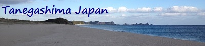
 Tanegashima Oceans Tanegashima Oceans
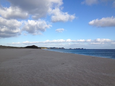
Tanegashima is greatly affected by the Pacific Ocean which
works to moderate temperatures on the island. Air temperature
differences of only a few degrees from morning to night and
from day to day are typical, especially during the Summer
months. |
|
Pacific
Ocean
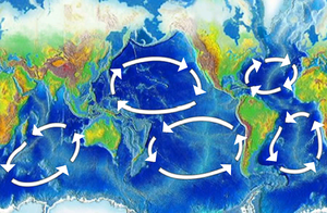
The Pacific Ocean is the largest of the Earth's oceanic
divisions. It extends from the Arctic Ocean in the north to
the Southern Ocean (or, depending on definition, to
Antarctica) in the south, bounded by Asia and Australia in
the west, and the Americas in the east.
At 165.25 million square kilometres (63.8 million square
miles) in area, this largest division of the World Ocean –
and, in turn, the hydrosphere – covers about 46% of the
Earth's water surface and about one-third of its total
surface area, making it larger than all of the Earth's land
area combined. The equator subdivides it into the North
Pacific Ocean and South Pacific Ocean, with two exceptions:
the Galápagos and Gilbert Islands, while straddling the
equator, are deemed wholly within the South Pacific. The
Mariana Trench in the western North Pacific is the deepest
point in the world, reaching a depth of 10,911 metres
(35,797 ft).
Graphic - The Pacific
Ocean. |
|
East
China Sea
The East China Sea is a marginal sea east of China. It is a
part of the Pacific Ocean and covers an area of roughly
1,249,000 square kilometres (482,000 sq mi).
The East China Sea is bounded on the east by Kyūshū and the
Ryukyu Islands of Japan, on the south by the South China
Sea, and on the west by the Asian continent. It connects
with the Sea of Japan through the Korea Strait; it opens in
the north to the Yellow Sea.
Graphic - The East China
Sea, showing surrounding regions, islands, cities, and seas. |
East
China Sea Borders
States with borders on the sea (clockwise from north)
include: South Korea, Japan, Republic of China (Taiwan) and
the People's Republic of China.
The International Hydrographic Organization defines the
limits of the "Eastern China Sea (Tung Hai)" as follows: |
On the South.
The Northern limit of the South China Sea [From Fuki Kaku
the North point of Formosa to Kiushan Tao (Turnabout Island)
on to the South point of Haitan Tao (25°25' N) and thence
Westward on the parallel of 25°24' North to the coast of
Fukien], thence from Santyo the Northeastern point of
Formosa to the West point of Yonakuni Island and thence to
Haderuma Sima (24°03′ N, 123°47′ E).
On the East.
From Haderuma Sima a line including the Miyako Retto to the
East point of Miyako Sima and thence to Okinan Kaku, the
Southern extremity of Okinawa Sima through this island to
Ada-Ko Sima (Sidmouth Island) on to the East point of Kikai
Sima (28°20' N) through Tanegashima (30°30' N) to the North
point thereof and on to Hi-Saki (31°17' N) in Kyusyu.
On the North.
From Nomo Saki (32°35' N) in Kyusyu to the South point of
Hukae Sima (Goto Retto) and on through this island to Ose
Saki (Cape Goto) and to Hunan Kan, the South point of Saisyu
To (Quelpart), through this island to its Western extreme
and thence along the parallel of 33°17' North to the
mainland.
On the West.
The mainland of China. |
|
|
Kuroshio
Current
Tanegashima is greatly affected by the Kuroshio Current. The
Kuroshio (黒潮 [ku͍ɽoɕio] "Black Tide") is a north-flowing
ocean current on the west side of the North Pacific Ocean.
It is similar to the Gulf Stream in the North Atlantic and
is part of the North Pacific ocean gyre. Like the Gulf
stream, it is a strong western boundary current.
Graphic - The Kuroshio
Current is the west side of the clockwise North Pacific
ocean gyre. |
 It
begins off the east coast of Taiwan and flows northeastward
past Japan, where it merges with the easterly drift of the
North Pacific Current. It is analogous to the Gulf Stream in
the Atlantic Ocean, transporting warm, tropical water
northward toward the polar region. It is sometimes known as
the Black Stream — the English translation of kuroshio and
an allusion to the deep blue of its water — and also as the
"Japan Current" (日本海流 Nihon Kairyū). It
begins off the east coast of Taiwan and flows northeastward
past Japan, where it merges with the easterly drift of the
North Pacific Current. It is analogous to the Gulf Stream in
the Atlantic Ocean, transporting warm, tropical water
northward toward the polar region. It is sometimes known as
the Black Stream — the English translation of kuroshio and
an allusion to the deep blue of its water — and also as the
"Japan Current" (日本海流 Nihon Kairyū).
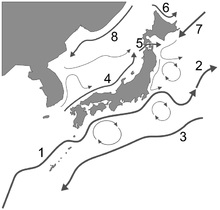
Graphic - The ocean
currents surrounding the Japanese archipelago:
1. Kuroshio 2. Kuroshio
extension 3. Kuroshio countercurrent 4. Tsushima Current 5.
Tsugaru Current 6. Sōya Current 7. Oyashio 8. Liman Current.
The path of Kuroshio south of Japan is reported every day.
Its counterparts are the North Pacific Current to the north,
the California Current to the east, and the North Equatorial
Current to the south. The warm waters of the Kuroshio
Current sustain the coral reefs of Japan, the northernmost
coral reefs in the world. The branch into the Sea of Japan
is called Tsushima Current (対馬海流 Tsushima Kairyū). |
|
|
|
|
|