|
|
|
|
|
|
|
|
 Tanegashima Biking Tanegashima Biking
Tanegashima is definitely a great place if you are into
biking. Fantastic rides can be found along the coastline
affording beautiful panoramic views. If you plan to go
riding around the interior of the island be prepared for a
workout as the sloping roads can be a bit challenging.
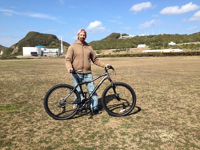
Picture - Me and my new
Haro mountain bike on a test ride at the Tanegashima Space
Center.
The rides on this page were made back in 2015 during our
first stay on the island. Now way too busy for bike riding but hoping to get
back to it at some point, at which time, many more bike routes will be added. |
|
Minamitane Ride
This ride covers route 75 in Minamitane stretching from Shimama Port to the
Tanegashima Space Center.
Note: These rides assume an average bike riding
speed (24 kph, 15 mph) typical of an avid rider on a paved road. These rides
contain sloping topography and may take considerably longer to navigate for some
riders.
Click to view this ride on a full size Google Map
The following is the ride in more detail and the ride separated into shorter and
easier rides. |
|
Shimama Port to Space Center
Distance: 25.7 km (16.0 miles) - one way
Time: About 64 minutes (24 kph, 15 mph)
Click to view this ride on a full size Google Map
Details:
From Shimama Port the road slopes up to over 40 meters in
elevation along route 58. After turning right onto route 75
the road continues to slope up to over 60 meters and then
steeply slopes back down until the coast with an incredible
high elevation view of the ocean.
Upon reaching the coast the road levels out and winds
through small quaint fishing villages. Numerous shrines can
be seen along the way.
After passing the Seikai post office the road will
eventually begins sloping up again and away from the coast
to an elevation of over 100 meters. This section of the ride
is fairly difficult.
The road levels out for a short period and then slopes down
steeply once again veering towards the coast and dropping to
en elevation of a little over 40 meters.
The ride is pretty nice from this point with a gradual
elevation gain to over 80 meters. The road eventually slopes
down steeply past the Maenohama overlook view point to less
than 20 meters in elevation. From this point the ride is
easy and continues alongside coastal farms.
Eventually route 75 turns right and leads to route 586 where
the ride turns into a winding downward and upward sloping
road through beautiful cut sandstone topography until
reaching the Tanegashima Space Center. |
Shimama Port to Maenohama
Beach
Distance: 18.3 km (11.4 miles) - one way
Time: About 45 minutes (24 kph, 15 mph)
Click to view this ride on a full size Google Map
Details:
From Shimama Port the road slopes up to over 40 meters in
elevation along route 58. After turning right onto route 75
the road continues to slope up to over 60 meters and then
steeply slopes back down until the coast with an incredible
high elevation view of the ocean.
Upon reaching the coast the road levels out and winds
through small quaint fishing villages. Numerous shrines can
be seen along the way.
After passing the Seikai post office the road will
eventually begins sloping up again and away from the coast
to an elevation of over 100 meters. This section of the ride
is fairly difficult.
The road levels out for a short period and then slopes down
steeply once again veering towards the coast and dropping to
en elevation of a little over 40 meters.
The ride is pretty nice from this point with a gradual
elevation gain to over 80 meters. The road eventually slopes
down steeply past the Maenohama overlook view point to less
than 20 meters in elevation. From this point the ride is
easy and continues alongside coastal farms.
The access road to Maenohama passes through mostly rice
farms and then a small forest before turning and continuing
on to the beach. |
Shimama Port to Kadokura Cape
Distance: 15.8 km (9.8 miles) - one way
Time: About 40 minutes (24 kph, 15 mph)
Click to view this ride on a full size Google Map
Details:
From Shimama Port the road slopes up to over 40 meters in
elevation along route 58. After turning right onto route 75
the road continues to slope up to over 60 meters and then
steeply slopes back down until the coast with an incredible
high elevation view of the ocean.
Upon reaching the coast the road levels out and winds
through small quaint fishing villages. Numerous shrines can
be seen along the way.
After passing the Seikai post office the road eventually
begins sloping up again and away from the coast to an
elevation of over 100 meters. This section of the ride is
fairly difficult.
The road levels out for a short period and then slopes down
steeply once again veering towards the coast and dropping to
an elevation of a little over 40 meters.
The ride is pretty nice from this point with a gradual
elevation gain to over 80 meters before reaching the
Kadokura access road. Glimpses of the coast dot this section
of the ride.
The access road is a gentle slope down to an elevation of
about 60 meters before reaching the entrance to Kadokura
Cape. Sunrise views overlooking Maenohama beach and the
ocean are spectacular from the farms along this road. |
|
Kadokura Cape to Space Center
Distance: 11.4 km (7.1 miles) - one way
Time: About 29 minutes (24 kph, 15 mph)
Click to view this ride on a full size Google Map
Details:
The access road from Kadokura Cape is a gentle slope up from
an elevation of about 60 meters to over 80 meters at the
main road. Sunrise views overlooking Maenohama beach and the
ocean are spectacular from the farms along this road.
The ride is pretty nice from this point. The road eventually slopes
down steeply past the Maenohama overlook view point to less
than 20 meters in elevation. From this point the ride is
easy and continues alongside coastal farms.
Eventually route 75 turns right and leads to route 586 where
the ride turns into a winding downward and upward sloping
road through beautiful cut sandstone topography until
reaching the Tanegashima Space Center. |
Kadokura Cape to Maenohama
Beach
Distance: 4 km (2.5 miles) - one way
Time: About 10 minutes (24 kph, 15 mph)
Click to view this ride on a full size Google Map
Details:
The access road from Kadokura Cape is a gentle slope up from
an elevation of about 60 meters to over 80 meters at the
main road. Sunrise views overlooking Maenohama beach and the
ocean are spectacular from the farms along this road.
The ride is pretty nice from this point. The road eventually slopes
down steeply past the Maenohama overlook view point to less
than 20 meters in elevation. From this point the ride is
easy and continues alongside coastal farms.
The access road to Maenohama passes through mostly rice
farms and then a small forest before turning and continuing
on to the beach. |
Maenohama
Beach to Space Center
Distance: 8.5 km (5.3 miles) - one way
Time: About 21 minutes (24 kph, 15 mph)
Click to view this ride on a full size Google Map
Details:
From Maenohama beach, the access road passes through a small forest
and then mostly rice farms before reaching the main road.
Eventually route 75 turns right and leads to route 586 where
the ride turns into a winding downward and upward sloping
road through beautiful cut sandstone topography until
reaching the Tanegashima Space Center. |
|
|
|