|
|
|
|
|
|
|
|
 Tanegashima
GeologyPicture Tanegashima
GeologyPicture |
|
 Sedimentary
Deposits Sedimentary
Deposits
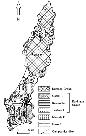
Apparently the consensus is that Tanegashima is composed of
mostly sedimentary deposits of the Kumage group dating back
some 60 million years, the beginning of the Paleogene period
which began 66 million and ended 23 million years ago.
These deposits consisted of sand and mud which over time
were compressed and eventually became the sandstone and
shale evident over much of the island today.
The Paleogene comprises the first part of the Cenozoic Era.
Lasting 43 million years, the Paleogene is most notable as
being the time in which mammals evolved from relatively
small, simple forms into a large group of diverse animals
before the Cretaceous-Paleogene extinction event that
ended the preceding Cretaceous Period.
Picture - A map of
Tanegashima showing the extent of the Kumage group which has
been overlain with several other geological formations
dispersed throughout the island.
Then approximately 14 million years ago Tanegashima and
neighboring Yakushima began to get pushed up due to magmatic
activity. The Yakushima granite is an intrusion into the
sedimentary deposits of the Kumage group. This intrusion
pushed Yakushima up and the
island continues to rise even today.
The forces
which pushed Yakushima mountains up to their present height
of over 1,900 meters (the highest point on the island is
Miyanouradake (宮之浦岳), with a height of 1,935 meters (6,348
ft)) had little affect on Tanegashima. In contrast the
highest point on Tanegashima is a mere 282 meters (925 ft)
above sea level. |
|
 Chikura
Caves Chikura
Caves
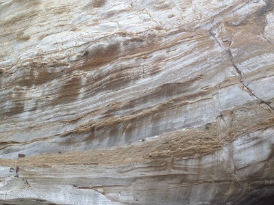
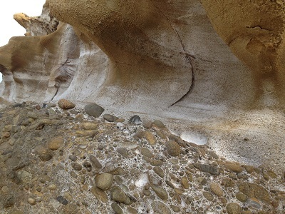
Probably the best place to really see the effects of
geological uplift and erosion is on the southern coast of
the island and at the famous Chikura Caves, located at
Hamada Beach.
Picture - A rocky
section of an outcrop and Chikura Caves.
The caves are particularly interesting because you can see
the different sedimentary strata close up. The caves were
uplifted and eroded over millions of years into the forms
that you see today. |
|
|
|
|
|