|
|
|
|
|
|
|
|
 Nishinoomote City Nishinoomote City
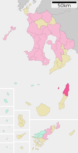
Nishinoomote (西之表市 Nishinoomote-shi) is a city (dark pink on
the map) located on
the island of Tanegashima, in Kagoshima Prefecture, Japan.
As of June 2013, the city has an estimated population of
16,418 and a population density of 79.8 persons per km². The
total area is 205.75 km².
Nishinoomote, located on the northern portion of
Tanegashima, is bordered by the East China Sea to the west
and the Pacific Ocean to the east, and by the Osumi Strait
separating Tanegashima from the Kyushu mainland. The city
also includes the offshore island of Mageshima within its
borders.
Nishinoomote has a humid subtropical climate (Köppen climate
classification Cfa) with long, hot, humid summers and mild
winters. Precipitation is abundant throughout the year, with
particularly heavy rainfall in May, June, August and
September. The area is subject to frequent typhoons.
Kitatane Village was established on April 1, 1889. It was
elevated to town status on April 1, 1926 and renamed
Nishinoomote. Towards the end of World War II, the town was
garrisoned by a 12,000-man force from the Imperial Japanese
Army and was thus subjected to bombing by the United States
Navy in 1945. As with all of the Amami Islands, the town
came under the administration of the United States from July
1, 1946 to December 25, 1953. It was elevated to city status
on October 1, 1958.
Nishinoomote Port is a regional transportation hub, with
frequent ferry service to Kagoshima, Tokyo, Kobe, and Osaka,
as well as Okinawa and the other Osumi islands.
|
|
Nishinoomote
City Districts
Nishinoomote city encompasses seven separate districts including: Anjo, Anno,
Genna, Iseki, Kunigami, Nishinoomote, and Sumiyoshi. The districts are listed in
alphabetical order and the maps show the district boundaries. |
Anjo District
The Anjo district covers a southeastern section of Nishinoomote city extending
to the east coast of Tanegashima. |
Anno District
The Anno district covers an eastern section of Nishinoomote city extending to
the east coast of Tanegashima. |
Genna District
The Genna district covers an eastern section of Nishinoomote city extending to
the east coast of Tanegashima. |
Iseki District
The Iseki district covers a northwest section of Nishinoomote city extending to
the east coast of Tanegashima. |
Kunigami District
The Kunigami district covers the northernmost section of Nishinoomote city
extending from the west coast to the east coast and including the northern tip
of Tanegashima. |
Nishinoomote District
The Nishinoomote district covers the entire area of Nishinoomote city. This
includes all the smaller individual districts which make up the Nishinoomote
district. |
Sumiyoshi District
The Sumiyoshi district covers a southwest section of Nishinoomote city extending
to the west coast of Tanegashima. |
|
 Nishinoomote City Information Nishinoomote City Information |
Geographic Coordinates:
30°41′N 131°01′E
Country: Japan
Region: Kyushu (Ōsumi Islands)
Prefecture: Kagoshima
Prefecture
Area Total: 205.75 km2 (79.44
sq mi)
Population (June 1, 2013) Total:
16,418
Population (June 1, 2013) Density
Total: 79.8/km2 (207/sq mi)
Time zone: Japan Standard Time
(UTC+9)
Tree: Akō (Ficus superba Miq.
var. japonica Miq.)
Flower: Lilium longiflorum
Flowering Tree: Chinese
hibiscus
Insect: Great Orange Tip
Phone number: 0997-22-1111
Address: 7612 Nishinoomote,
Nishinoomote-shi, Kagoshima-ken 891-3193 |
|
|
|
Sister cities |
 Japan
- Isa, Kagoshima, since November 10, 1962 Japan
- Isa, Kagoshima, since November 10, 1962 |
|
Japan
- Sakai, Osaka, since October 18, 1986 |
|
Japan
- Nagahama, Shiga, since October 8, 1987 |
 Portugal
- Vila do Bispo, Portugal, since October 1, 1993 (in
recognition of the fact that it was Fernão Mendes Pinto, a
Portuguese explorer, who claimed to be the first European to
set foot on Japan, and did so on Tanegashima in 1543.) Portugal
- Vila do Bispo, Portugal, since October 1, 1993 (in
recognition of the fact that it was Fernão Mendes Pinto, a
Portuguese explorer, who claimed to be the first European to
set foot on Japan, and did so on Tanegashima in 1543.) |
|
|
|
|
|
|
|